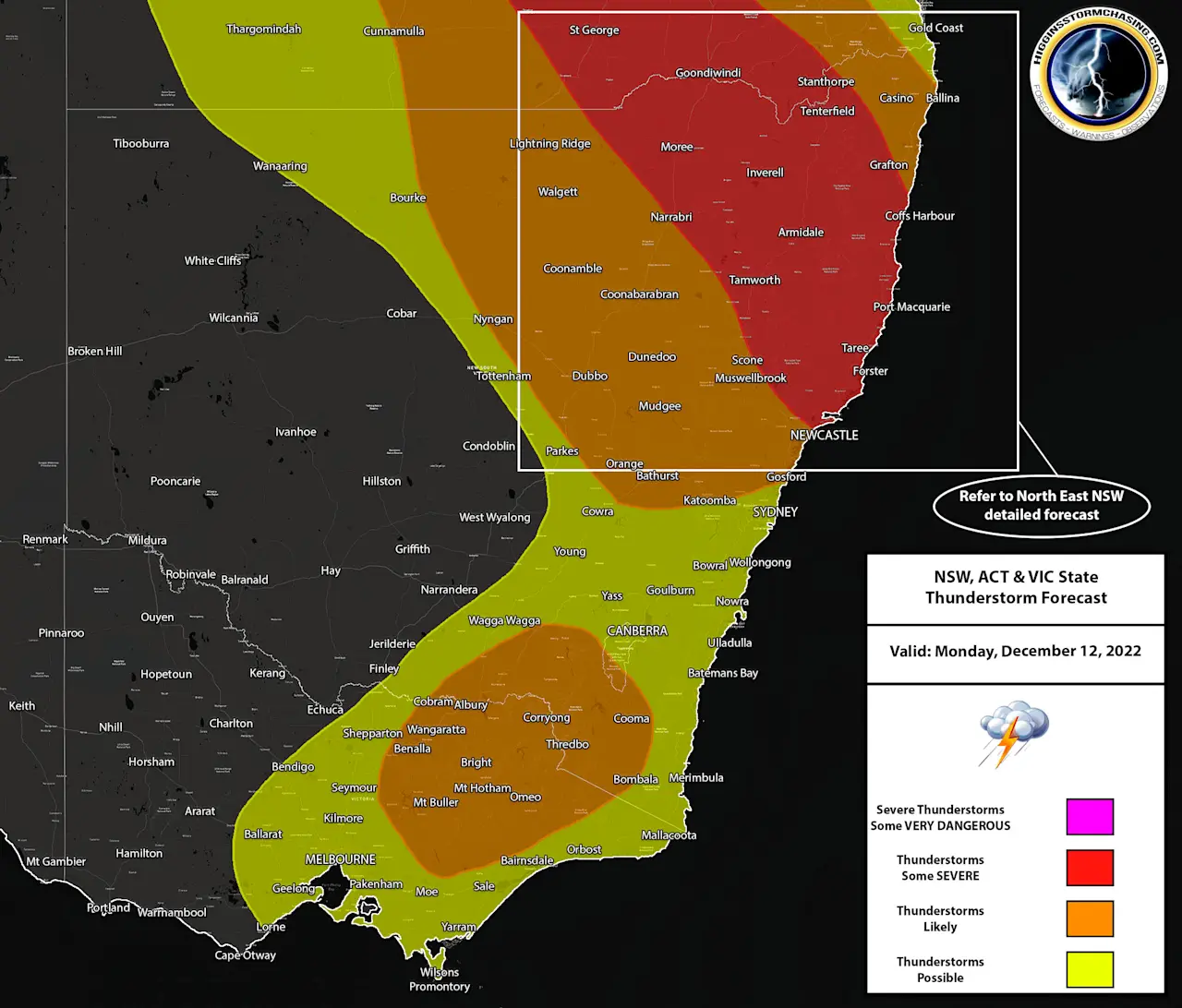
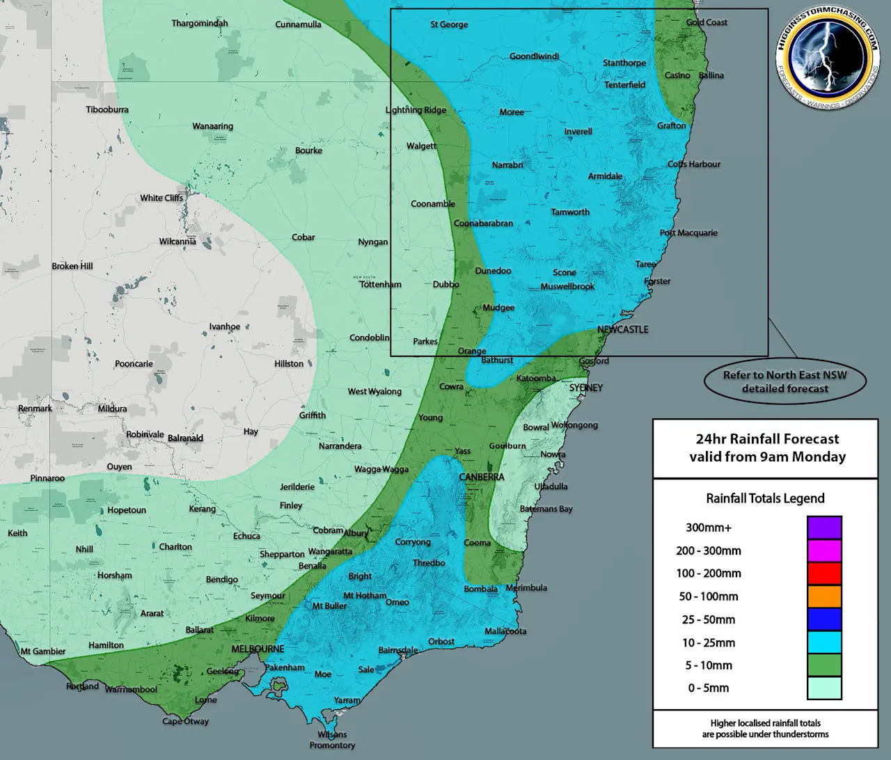
NSW: During the morning, a trough is expected to be situated over Central Eastern and Northern Inland NSW, with this trough continuing to move towards the East and through North East NSW during the afternoon and evening. This trough is expected to continue to draw in warm and humid air from the North, which will create a large area of instability over Northern and Eastern NSW, whilst upper level support and increased moisture from the South West are expected to help create further instability over Inland and Southern NSW. This combination is expected to produce ongoing showers and storms over Northern Inland, Central Inland, South Eastern and Central Eastern NSW during the morning. As the day progresses, storms are expected to become far more organised and likely over Northern and North Eastern NSW, with several cells likely becoming severe during there afternoon and into the evening / early night. Storms should push into the Far North East later in the night, but by this stage… they are expected to start running out of energy. Across Northern, North Eastern and Central Eastern NSW – any storms that become severe, are expected to produce damaging winds, heavy rain & large hail… with one or two supercells not ruled out which may contain giant hail and/or destructive winds. Widespread double digit accumulations are expected with some locally moderate to heavy falls also possible. Across Southern and South Eastern NSW, these storms are expected to contain lots of small hail, some gusty winds and a burst of heavy rainfall with further double digit accumulations likely. Eventually the South Westerly winds are expected to produce widespread fine conditions overnight across Inland NSW.
Maximums: 5-9ºc across the Southern Ranges. 17-22ºc across the Central Ranges. 18-22ºc across Southern Inland NSW. 18-26ºc across Southern Coastal NSW. 21-26ºc across Central Inland NSW. 22-25ºc across South West NSW. 22-27ºc across the Northern Ranges. 22-31ºc across Central Coastal NSW. 24-29ºc across North West NSW. 28-35ºc across Northern Inland NSW. 29-34ºc across Northern Coastal NSW.
ACT: West to South West winds are expected to dominate the region throughout the day and into the night. These winds are expected to draw in increased moisture over the region, which will combine with some upper level support to generate weak instability over the region. This should lead to at least some isolated to scattered showers across the ACT throughout the day and into the night.. however, some isolated storms are also possible (more likely further West and South) across the region. Any storms that manage to develop, are expected to produce some gusty winds, small hail and a burst of heavy rainfall.
Maximums: 14-19ºc across the ACT.
VIC: West to South West winds are expected to dominate the entire State during the day, with these winds combining with some upper level support over the Eastern half of the State in particular. This combination is expected to help produce enough instability that some isolated storms become likely during the afternoon and evening across areas away from the Coastline over Eastern VIC and across the North East. Any storms that develop are expected to produce a burst of heavy rain, strong winds and small hail… with further scattered showers across these areas also, which should boost rainfall accumulations for the day. Further showers are expected over Central and South West V IC, with lighter falls across these areas in comparison to Eastern VIC.
Maximums: 4-7ºc across the North East Alpine. 13-18ºc across Central VIC. 14-19ºc across Eastern VIC. 16-20ºc across Western VIC. 16-21ºc across Northern VIC. 20-23ºc across North West VIC.