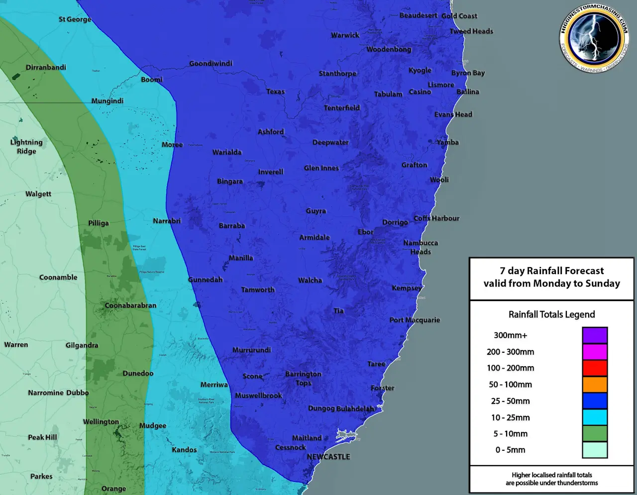
Valid from Monday 12th of December to Sunday 18th of December 2022
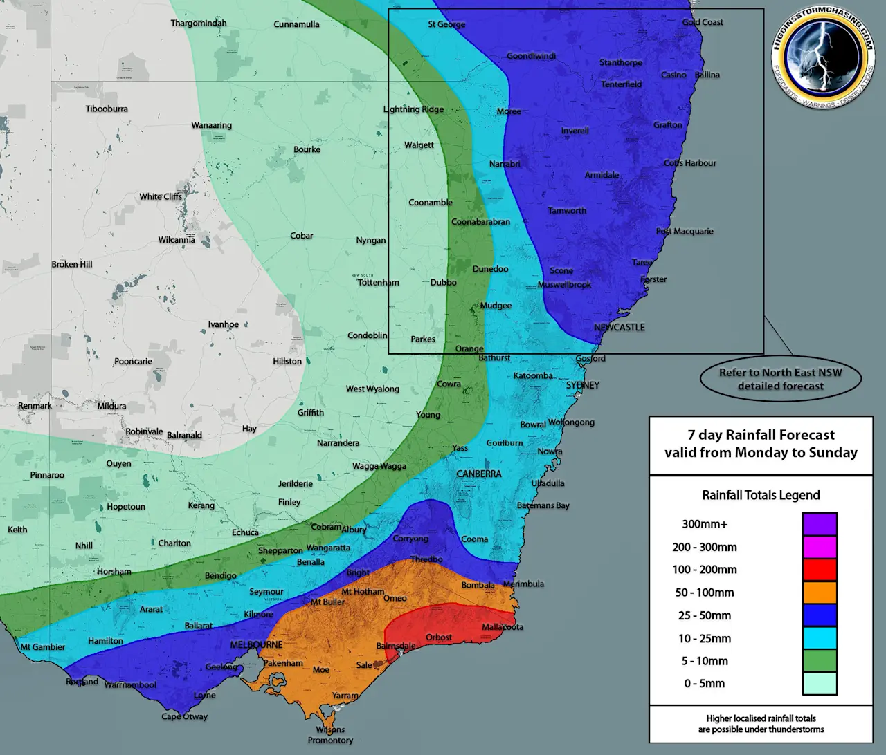
NSW: Across the course of the week, rainfall is expected to be heavily focused over the Eastern half of the State and more specifically over South Eastern NSW where some heavy falls may reside. During Monday the focus will be over North Eastern and South Eastern NSW with storms moving through both areas and some possible moderate falls over North East NSW and double digit accumulations over South East NSW. Tuesday should see showers and some possible double digit accumulations remain over Far South East NSW with some showers and possible storms over Far North East NSW. Wednesday through to Friday is expected to produce additional Coastal showers over most of Coastal NSW, with light accumulations each day that are expected to add up over the course of the 5-day period. The better falls are more likely yo be over South Eastern NSW where moisture content will be slightly deeper. Across Inland NSW, outside of Monday and Tuesday where various areas may see some form of precipitation… next to no rainfall is expected for the remainder of the week. Falls of up to 50-70mm are expected over Far South East NSW during the week, with broader falls of 25mm+ over South Eastern and North Eastern NSW and double digit accumulations over Eastern NSW.
ACT: Double digit accumulations are expected across the region during the week, with rainfall expected most days across the ACT – but most rainfall likely occurring on Monday and into Tuesday. During Monday, some showers and storms are expected across the region, with Tuesday seeing additional showers and possible storms. From Wednesday to Sunday, showers are possible each day and more likely on others, with only light falls expected on a day-to-day basis which should add up as the week progresses. Falls of 15-25mm are likely over the region across the week, with higher falls possible under the heavier activity earlier in the week.
VIC: Heavy falls are expected across Eastern VIC during the week with relentless rainfall expected over these areas on a day-to-day basis. Showers and storms are likely over Eastern VIC on Monday with double digit accumulations likely, showers are expected over the rest of Northern and the Southern half of VIC. Showers and storms are likely over the Southern and Eastern halves of the State on Tuesday with double digit accumulations likely over Central and Eastern VIC. Showers and possible storms are expected over Eastern VIC on Wednesday with moderate falls becoming likely. Further showers and some double digit to moderate falls are expected over Eastern VIC on Thursday, with showers likely over Southern VIC. Showers are then likely over Southern and Eastern VIC on Friday, and across Eastern VIC on the weekend with further notable accumulations occurring… the rest of the State should remain fine over the week with much of North West VIC seeing next to no rainfall over the week as a whole. Widespread falls of 50-100mm are expected over Central and Eastern VIC across the week, with 100-150mm occurring over the East Gippsland and immediate surrounding areas. Falls of 25mm+ are expected over South West, North East and Northern VIC with lighter falls expanding further North and West.